tungwaiyip.info

home

about me

links

Blog

< August 2012 >
SuMoTuWeThFrSa
    1 2 3 4
5 6 7 8 91011
12131415161718
19202122232425
262728293031 

past articles »

Click for San Francisco, California Forecast

San Francisco, USA


Walking Distance Yardstick

It is not so straight forward to make a distance estimation when using online map. The tiny scale is hardly useful. So I have made some measurement base on some San Francisco landmark for use as a yardstick. The measurement is the approximate distance from the front entrance of the Ferry Building.

  • 100m - The Art and Craft Market by Justin Herman Square
  • 200m - The length of the Ferry building
  • 500m - Embarcadero BART at Beale St
  • 1 km - Montgomery BART at 2nd St
  • 3.2 km - Van Ness

Another rule of thumb is a brisk walk of 1 km takes about 10 minutes. So to walk to Van Ness, it should take a little more than 30 minutes. This number I have validated in my walk early this week.

2012.08.04 [] - comments


Angkor Geography

Just to follow up with more fun with Google Earth. I have captured another picture a short distance to the northeast of Angkor. The are many dots scattered in this territory that look like bomb craters. Unlike the fields to the south, there seems to have little trace of human in this area. What are these dots really?

Northeast of Angkor

From two independent sources I have found enough information to identify this geography feature. If you have the July 2009 issue of National Geographic, you can check the hand drawn map to see what have they depicted in the northeast area. I have also found one picture from Google Earth that gives ground level perspective. Unlike the Angkor templates of historical fame there aren't thousands of pictures taken there. I have to look hard to find one single picture. But what I saw confirms the illustration from National Geographic.

The answer is they are natural ponds. It appears that they only filled up seasonally. When the pictures was taken they appeared to be mostly dry.

2009.07.05 [] - comments


Angkor Travel

I have spent this evening travelling in the ancient city of Angkor. Unfortunately I am not able to set foot in this land yet. Instead I have visited Angkor virtually using Google Earth from my home. It is a small pity that I wasn't going there personally. But what an incredible experience does Google Earth provide! The aerial image gives me so much intelligence on this distance land that even travelling on the ground cannot achieve. He go here.

All this was prompted by an article on the collapsed of Angkor on the current issue of National Geographic. I launched Google Earth to find an image of modern day Angkor to compare with the illustration of a historical map. The glory of the 13th century city is still clearly visible from the satellite.

Angkor aerial view

The square at the center is the site of the ancient capital Angkor Thom, now filled with dense jungle in dark green color. The surrounding area are fields with little population. Siem Reap to the south is the only population center today. The most striking features on the map are several large rectangles. I have labeled three of them, the West Baray, East Baray and North Baray. They are actually enormous reservoir built in ancient time. The largest one West Baray measures 2 x 8 km. Today they are mostly filled up. There are still water in the west side of West Baray. Otherwise they are filled will fields. There are even roads and houses built within the Baray. National Geographic has suggested the failure of this water system during a mega-drought period is one reason for the decline of Angkor.

You can also find clusters of blue dots on the image. They point to pictures uploaded by users. These are actually enormously useful information. First of all you cannot fully understand the area by looking at the aerial picture alone. The user pictures give you detail ground level view and help you to understand some geographic features spotted from the sky. Secondly it tells you where tourists are going! An area with a dense cluster of blue dots are picture worthy places. This is an instant travel guide constructed automatically!

Since Google Earth has come out a few years ago, it has helped me so much in learning about places and geography. It is a really revolutionary tools!

2009.07.03 [, ] - comments


Is The Great Wall Visible From Space - An Aerial Survey with Google Earth

There is a saying that the Great Wall of China, an earthen fortifications stretching more than 6000km, is the only human-made structure visible from space. Is this a true claim? Unfortunately space tourism has not arrived yet, so we cannot fly over to verify it. But the next best thing, the Google Earth, is already here for free. Better yet, anyone can do an aerial survey simply from a home computer.

Let's go to Badaling(八達嶺), a mountain pass north of Beijing where all the tourists flock to see the restored section of the Great Wall. I have captured three pictures from altitude of 1km, 12km and 100km.

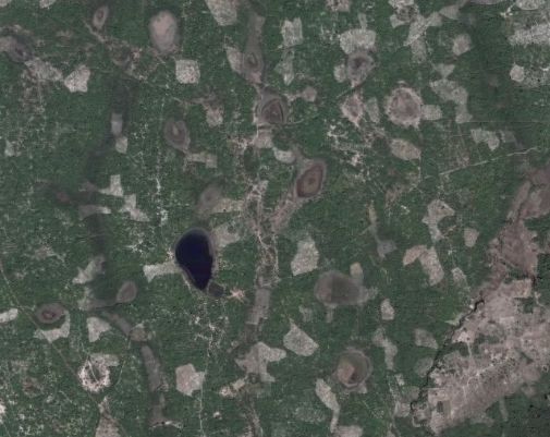
From the 1km picture, you can clearly see the wall and two square towers. The next picture is from 12km above, the cruising altitude of a 747 plane. The gray dot at the center is the park's entrance and a parking lot. The curvy line going from the lower side to upper left is a highway, not the Great Wall! If you look really carefully you can spot the Great Wall as a faint line along the ridge running from the lower left side to upper right side through the visitor's entrance. The Great Wall is already hardly visible from a 747.

Moving on to the third picture from 100km above, not quite from the space yet but from a low earth orbit. Not a trace of the wall nor the visitor's center is visible. The grayish area at the lower right hand corner is part of the Beijing metropolitan.


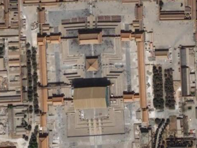
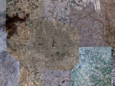
For comparison, let's do another survey on Beijing's Forbidden City. From 1km we can clearly see the imperial halls and courts. From 12km, the rectangular Forbidden City surrounded by a moat is a distinctly visible feature. Even from 100km, the Forbidden City still appear as a small pod in the middle next to a dark shape of the Beihai lake.


All these are really very logical. The Great Wall is perhaps 5 to 10 meters wide, most of them are now crumbling earth. The Forbidden City on the other hand, have a dimension of about 1000 meters by 800 meters. It is not a surprise that the Forbidden City is far more visible than the Great Wall.

Seeing is believing. The saying that the Great Wall is visible from space is unfortunately only an urban legend.

2007.11.30 [, ] - comments


Geography of the Middle East flash point

The latest conflict in Middle East has caused deep concern among the world. How can I relate events happening on the opposite side of the globe to myself? I decided to match the geography of the region to the San Francisco bay area, the place where I am living. Thanks Google Earth and GIMP, I can put them together side by side.

For all the troubles rises in the past decades, this region is relative small. The main map shows much of Israel, Lebanon and the West Bank. The inset shows the approximate extend of the nine county of San Francisco bay area. Their sizes are actually comparable. The distance from Beirut to Haifa is 130km and from Haifa to Tel Aviv is 84km. Similarly the distance from Sacramento to San Francisco is 124km and from San Francisco to San Jose is 67km.

The Gaza Strip is cut off from the bottom of the map. But it is shown here in the inset inside the inset under the same scale. Its size is comparable to the San Francisco Peninsular. The length of Gaza is about 41km, slightly shorter than the distance between San Francisco and Palo Alto (44km).

Here are some more figures. The combined area of Lebanon, Israel, West Bank and Gaza Strip has about 14.3 million people in the area of 39,000 sq km. The Bay area has about 7 million people in the area of 17,000 sq km.

With this in mind we can start to imagine. What is it like if fighting erupt in our home town? How would it affect your life when your safety is at risk and key infrastructure are damaged?

Furthermore, life in San Francisco bay area are in general peacefully and prosperous. Why isn't more conflicts happen here? What is the social and historical cause that make the conflicts in the middle east so insolvable? What would be the way out?

2006.07.20 [, ] - comments


Affluence has a color - Green

Affluence has a color - green. And by that I don't mean greenback.

I was checking the Google map one day. It strikes me how Atherton, a uber rich city in California, stands out with a greenish tone. Most other urban area I looked appear grayish.

Further up north your will find another green patch - Hillsborough.

P.S. If you don't see much color, you might want a better monitor. On my Acer LCD monitor the color looks very rich. But on a Dell laptop the same picture becomes very dull.

2006.06.02 [] - comments


Google map scale

It always frustrate me to find maps don't come with scale. It is particular important if you try to judge whether a route is within walking distance. Google map is an incredible tool. But it needs to show the scale too!

So I have decided to make my measurements and come up with some reasonable estimate. I will use the zoom control as the scale. Up to 9 zoom levels were measured with level 1 being the most detail. The distance between the center of + mark and the - mark, is shown below. Beware that the projected images near the poles (e.g. Helsinki,Finland) seems significantly distorted.

LevelDistance
1230m
2450m
3870m
41.7km
53.3km
66.4km
712km
824km
947km

2005.06.24 [] - comments


past articles »


BBC News


Prague gunman killed himself on roof as police approached (22 Dec 2023)


Bodycam footage shows police hunting Prague gunman (22 Dec 2023)


Alex Batty: Police launch abduction investigation into disappearance of British teen (22 Dec 2023)


Banksy stop sign drones art removed in London (22 Dec 2023)


Martin Kemp refunds disabled ticket after fans' difficulty with seller (22 Dec 2023)


Queues at Dover as Christmas getaway begins for millions (22 Dec 2023)


New £38,700 visa rule will be introduced in early 2025, says Rishi Sunak (22 Dec 2023)


UK at risk of recession after economy shrinks (22 Dec 2023)


Mohamed Al Bared: Student jailed for life for building IS drone (22 Dec 2023)


Andrew Tate denied request to visit ill mother in UK (22 Dec 2023)

more »


SF Gate

more »


Site feed Updated: 2023-Dec-22 09:00