
I have spent this evening travelling in the ancient city of Angkor. Unfortunately I am not able to set foot in this land yet. Instead I have visited Angkor virtually using Google Earth from my home. It is a small pity that I wasn't going there personally. But what an incredible experience does Google Earth provide! The aerial image gives me so much intelligence on this distance land that even travelling on the ground cannot achieve. He go here.
All this was prompted by an article on the collapsed of Angkor on the current issue of National Geographic. I launched Google Earth to find an image of modern day Angkor to compare with the illustration of a historical map. The glory of the 13th century city is still clearly visible from the satellite.
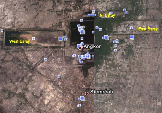
The square at the center is the site of the ancient capital Angkor Thom, now filled with dense jungle in dark green color. The surrounding area are fields with little population. Siem Reap to the south is the only population center today. The most striking features on the map are several large rectangles. I have labeled three of them, the West Baray, East Baray and North Baray. They are actually enormous reservoir built in ancient time. The largest one West Baray measures 2 x 8 km. Today they are mostly filled up. There are still water in the west side of West Baray. Otherwise they are filled will fields. There are even roads and houses built within the Baray. National Geographic has suggested the failure of this water system during a mega-drought period is one reason for the decline of Angkor.
You can also find clusters of blue dots on the image. They point to pictures uploaded by users. These are actually enormously useful information. First of all you cannot fully understand the area by looking at the aerial picture alone. The user pictures give you detail ground level view and help you to understand some geographic features spotted from the sky. Secondly it tells you where tourists are going! An area with a dense cluster of blue dots are picture worthy places. This is an instant travel guide constructed automatically!
Since Google Earth has come out a few years ago, it has helped me so much in learning about places and geography. It is a really revolutionary tools!
2009.07.03 - comments
 Site feed